
I’m late. The last of the red drained from the sky while I was in the shower; now the ridge behind me glows red as I sit facing east with my feet propped up.
Suddenly there’s a distant boom, very low-frequency, comparable in pitch to the drumming of a ruffed grouse. Maybe it’s more of a rumble than a boom – I feel it as much as I hear it. What the hell was that?
A minute later, another boom. The kind that rattles glass in windows, shakes plates from plate rails.
A third boom. I can feel it in my molars, almost. I decide they must be blasting at the limestone quarry two miles away, although usually it’s a higher-pitched sound, and the direction of origin isn’t nearly so difficult to pinpoint. A fire siren starts up and dies.
Another boom. I’m not wearing my watch, but they seem to be spaced about a minute apart. I think of our friends in the small village next to the quarry, how stressful it must be to have this blasting going on while they’re getting ready to go off to work. I recall a brief lecture on strip mining and quarrying by one of the Pennsylvania Chapter of the Sierra Club’s most knowledgeable activists, at a meeting just last month. “Blasting is an art, not a science,” she said. “Or you could say that each new hole requires a brand-new science.”
Boom. Again a fire siren wails once and falls silent. Is this what it felt like to be in Sarajevo on August 25, 1992? Such a calm morning! And then… Coming out of nowhere, like the hotel bombing in Lebanon last month that killed the former president. Prompting a sudden sick feeling in the pit of the stomach for all those who came of age during the civil war.
Boom. If this were still the Cold War, I’d be wondering, Is this it? Instead I’m thinking Al Qaeda, payback for Abu Ghraib…
Pick your disaster. News of the recent earthquake off Sumatra prompts recollections of the one major earthquake I experienced, in Taiwan, 1986 – also a middle-of-the-night thing. A violent shaking of something one had always been taught to regard as inert and unchanging. The exhilaration I felt, against all reason – chalk it up to a neurotic/religious temperament, perhaps. I’m an awe junky, I admit it. The earth is alive! I remember exulting – silently, so as not to alarm my seven roommates, all of whom immediately scrambled out of their bunks and poured into the hall, talking excitedly in Fujianese. Other people told me they had run out into the street, watched buildings and lampposts sway. One even saw ball lightning. I was so jealous.
Boom. The sound comes less from the air than out of the ground. Perhaps they are blasting deeper than usual, or have started on a new stratum. The limestone beds are lower Ordovician, and lie at perhaps a 15-degree angle. My house sits in upper Ordovician, on nearly vertical strata of the fossil-free Juniata formation. A mass extinction of unknown origin 443.5 million years ago is used to mark the end of the Ordovician period. Thus, it’s no exaggeration to say that cataclysmic disaster is written right into the stone here. But more to the point, the sharp plunging of these strata means that if vibrations from the quarry followed bedding lines alone, they would travel deep into the earth, a mile or more beneath my front porch. That may account for my impression that the sound is emanating from the ground, from all directions. In addition, fracture traces associated with a nearby, inactive fault craze the rocks on either side of the water gap, and it’s hard to believe these lineaments don’t also act as conduits for sound.
I first learned about this back in the 70s, when a geologist from Penn State approached my parents about burying an instrument called a tiltmeter at the top of our field, a mile and a half from the fault. A second tiltmeter was buried a comparable distance in the opposite direction. Up until then, like most people I had associated faults with seismically active regions at the edges of continental plates, such as the Pacific rim. But the first generation of Landsat photos had revealed a maze of intracontinental faults and lineaments, as well.
A tiltmeter is like a seismograph, they explained, but way more sensitive. The idea was to measure differential movements along the fault in response to the same, uniform stimuli – most notably, the tides. It really fired my ten-year-old imagination to learn that land as well as water responds to the moon’s gravitational tug with daily and monthly fluctuations: earth tides, they called them. Even when it isn’t shimmying in some temblor or quarry blast, the ground is far less firm than we like to think.
Another source of movement preceptible to the tiltmeter was the shrinking or expanding of soil in response to changes in temperature. My brothers and I were easily persuaded to help out by taking daily readings of high and low temperatures with a special thermometer they lent us. And they let us watch and ply them with questions on the momentous day when contractors dragged a huge drilling rig up our narrow, winding driveway and clear to the top of the field.
The tiltmeter was planted deep, never to be removed. There’s still a noticeable depression there, if you know where to look. For a long time I walked softly whenever I passed the spot, mindful that my footsteps were being recorded (or at least registered – I think the radio transmitter failed in less than a year). They told us not to worry, though – anything like that would be automatically discounted, off the chart. For something sensitive enough to “hear” the moon, even the footsteps of an ant would be deafening, they said.
Boom. What would it be like if an earthquake struck here, in the east? It’s not impossible. Earthquakes in seismically inactive regions are rare, but they can be devastating. Here’s a website with a list of the major earthquakes that have struck the midwestern and eastern United States and eastern Canada in historical times. Most notably, in late 1811 and early 1812, “New Madrid, Missouri, experienced the three largest earthquakes known to have occurred in North America (magnitudes estimated between 7.2 and 8.3) and 203 damaging aftershocks. Soil liquefaction occurred.” The price for greater stability is more violent cataclysm, when it comes. Deep stucture is no guarantee of permanence.
The website’s map does locate Pennsylvania within a zone of minor risk of damage from earthquakes. But as an article by science writer Robert Roy Britt on Space.com makes clear, it’s extremely difficult to know whether a given fault is truly inactive, if the periodicity of significant seismic activity is measured in thousands of years.
Britt’s article focuses on a plateau area of upstate New York, but many of the lessons would apply here, as well. The scientist featured in the article, Robert Jacobi, has developed methods to detect slight activity along faults based on subtle clues that would be invisible to both satellites and tiltmeters, such as “a long row of dead, dying or stressed plants; maybe a hint of out-of-place autumn color skipping along the top of a forest canopy. … A leaning tree … can indicate that a fault is slipping quietly over time, possibly building stress that might give way in a sudden snap.”
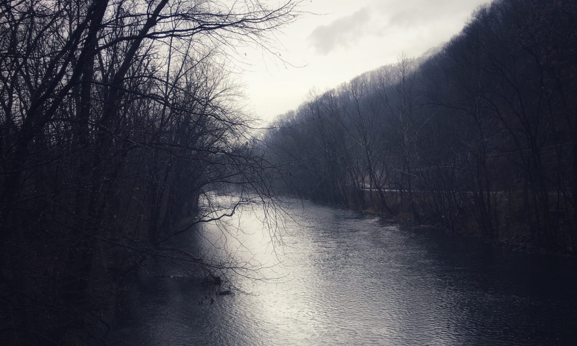
Our local lineament can be traced simply by noting the course of the Little Juniata River from Tyrone southeast to Mount Union. This is not uncommon.
“Faults chew up the ground, and so the ground is more susceptible to erosion – so many streams follow faults and fractures,” Jacobi said.
Variations in plant species or health can also be indicators: Stressed vegetation blooms later in the spring and turns color earlier in the fall.
“Some of these lineaments are there because faults conduct water and soil gas,” Jacobi said. “They conduct fluids and gases that will make trees and grass respond differently.”
Even within a forest canopy, scientists can pick out differences by flying over a region at various times of the year. In drier areas, where there is little vegetation, what greenery there is typically follows fault lines, where water reaches the surface.
From airplanes, readings of magnetic fields emanating from rock below helped Jacobi’s team calculate that some of the faults extended several miles (kilometers) below the surface. Matching their results with known faults in the far north of the study area helped show the method was reliable.
I’m fascinated by the notion that something virtually instantaneous on a geological time scale – seasonal changes in the growth of grass and trees – can be used to detect glacially slow movements along structures untold millions of years in age.
The booming stopped after about ten minutes. Three hours later, it’s a calm morning. I decided to ignore the red sunrise and hang out laundry anyway, choosing to believe an online forecast for sun and temperatures in the 60s. But in the back of my mind on days like this there’s always a little voice whispering, Don’t trust it. Anything can happen. We’re all living on groundless hopes, on borrowed time. The world can break.